

Visualizing Every US State Resized Based On Population
The U.S. is the world’s fourth-largest country by total area, third by land area, and is home to around 340 million people.
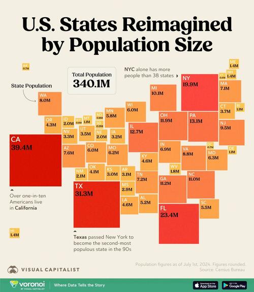
But nearly one-third of those people live in just three states: California, Texas, and New York.
This graphic, via Visual Capitalist’s Pallavi Rao, reimagines the usual U.S. map with the states resized based on their populations. Data is from the Census Bureau, as of 2024.
Alaska Isn’t the Largest Anymore
If sized by population, Alaska would be the third-smallest state (fourth if counting D.C.) in the country.
This is a far cry from its top of the rankings as America’s largest state by area (665,284 sq. miles).
| 1 | California | CA | 39.4M |
| 2 | Texas | TX | 31.3M |
| 3 | Florida | FL | 23.4M |
| 4 | New York | NY | 19.9M |
| 5 | Pennsylvania | PA | 13.1M |
| 6 | Illinois | IL | 12.7M |
| 7 | Ohio | OH | 11.9M |
| 8 | Georgia | GA | 11.2M |
| 9 | North Carolina | NC | 11.0M |
| 10 | Michigan | MI | 10.1M |
| 11 | New Jersey | NJ | 9.5M |
| 12 | Virginia | VA | 8.8M |
| 13 | Washington | WA | 8.0M |
| 14 | Arizona | AZ | 7.6M |
| 15 | Tennessee | TN | 7.2M |
| 16 | Massachusetts | MA | 7.1M |
| 17 | Indiana | IN | 6.9M |
| 18 | Maryland | MD | 6.3M |
| 19 | Missouri | MO | 6.2M |
| 20 | Wisconsin | WI | 6.0M |
| 21 | Colorado | CO | 6.0M |
| 22 | Minnesota | MN | 5.8M |
| 23 | South Carolina | SC | 5.5M |
| 24 | Alabama | AL | 5.2M |
| 25 | Louisiana | LA | 4.6M |
| 26 | Kentucky | KY | 4.6M |
| 27 | Oregon | OR | 4.3M |
| 28 | Oklahoma | OK | 4.1M |
| 29 | Connecticut | CT | 3.7M |
| 30 | Utah | UT | 3.5M |
| 31 | Nevada | NV | 3.3M |
| 32 | Iowa | IA | 3.2M |
| 33 | Arkansas | AR | 3.1M |
| 34 | Kansas | KS | 3.0M |
| 35 | Mississippi | MS | 2.9M |
| 36 | New Mexico | NM | 2.1M |
| 37 | Nebraska | NE | 2.0M |
| 38 | Idaho | ID | 2.0M |
| 39 | West Virginia | WV | 1.8M |
| 40 | Hawaii | HI | 1.4M |
| 41 | New Hampshire | NH | 1.4M |
| 42 | Maine | ME | 1.4M |
| 43 | Montana | MT | 1.1M |
| 44 | Rhode Island | RI | 1.1M |
| 45 | Delaware | DE | 1.1M |
| 46 | South Dakota | SD | 0.9M |
| 47 | North Dakota | ND | 0.8M |
| 48 | Alaska | AK | 0.7M |
| 49 | District of Columbia | DC | 0.7M |
| 50 | Vermont | VT | 0.6M |
| 51 | Wyoming | WY | 0.6M |
Note: Population figures are from July 1st, 2024.
On the other hand, a big gainer from putting people in perspective is Florida which is 22nd by size, but third by population.
The benefit of redrawing the map with population in mind, is that it’s easier to see where people actually live.
Several big states towards the west of the country, (Wyoming, the Dakotas, Montana) are actually home to less than four million people collectively. Most of the land is taken up by parks and farmland.
In fact New York City alone has more people (8.5 million) than 38 states.
Land Doesn’t Vote, People Do
This redrawing is also particularly useful in the context of the U.S. specifically.
Rural areas with low populations can sometimes have outsized political influence due to structures like the Electoral College or the Senate.
And when densely populated urban areas often lean one way politically, and sparsely populated rural regions lean another, then the gap between population-based representation and geographic-based influence is even more pronounced.
Not only is Texas the second-most populous state, it’s gaining people from the rest of the country. Check out: Net Migration Between States to see how many moved people to the Lone Star State in 2023.
Tyler Durden
Wed, 02/19/2025 – 22:20